


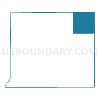
Voting District 1494702000001, St. Joseph County, Michigan
About
Outline

Summary
| Unique Area Identifier | 599503 |
| Name | Voting District 1494702000001 |
| County | St. Joseph County |
| State | Michigan |
| Area (square miles) | 36.19 |
| Land Area (square miles) | 35.49 |
| Water Area (square miles) | 0.70 |
| % of Land Area | 98.08 |
| % of Water Area | 1.92 |
| Latitude of the Internal Point | 42.02814580 |
| Longtitude of the Internal Point | -85.35445030 |
Maps

Graphs
Select a template below for downloading or customizing gragh for Voting District 1494702000001, St. Joseph County, Michigan


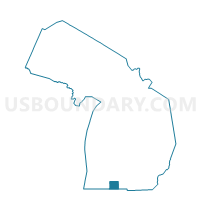
Neighbors
Neighoring Voting District (by Name) Neighboring Voting District on the Map
- Voting District 0235240000001, Branch County, MI
- Voting District 0237344000001, Branch County, MI
- Voting District 0250390000001B, Calhoun County, MI
- Voting District 0770992000002, Kalamazoo County, MI
- Voting District 0778284000001, Kalamazoo County, MI
- Voting District 1491737000001, St. Joseph County, MI
- Voting District 1495300000001, St. Joseph County, MI
- Voting District 1495940000001, St. Joseph County, MI
Top 10 Neighboring County Subdivision (by Population) Neighboring County Subdivision on the Map
- Brady township, Kalamazoo County, MI (4,248)
- Nottawa township, St. Joseph County, MI (3,858)
- Colon township, St. Joseph County, MI (3,329)
- Mendon township, St. Joseph County, MI (2,719)
- Athens township, Calhoun County, MI (2,554)
- Sherwood township, Branch County, MI (2,094)
- Wakeshma township, Kalamazoo County, MI (1,301)
- Matteson township, Branch County, MI (1,218)
- Leonidas township, St. Joseph County, MI (1,185)
Top 10 Neighboring Unified School District (by Population) Neighboring Unified School District on the Map
- Vicksburg Community Schools, MI (14,867)
- Colon Community School District, MI (5,637)
- Athens Area Schools, MI (4,785)
- Mendon Community School District, MI (3,620)
Top 10 Neighboring State Legislative District Lower Chamber (by Population) Neighboring State Legislative District Lower Chamber on the Map
- State House District 63, MI (96,333)
- State House District 59, MI (95,808)
- State House District 62, MI (93,343)
- State House District 58, MI (91,936)
Top 10 Neighboring State Legislative District Upper Chamber (by Population) Neighboring State Legislative District Upper Chamber on the Map
- State Senate District 20, MI (269,554)
- State Senate District 16, MI (253,123)
- State Senate District 19, MI (251,432)
Top 10 Neighboring 111th Congressional District (by Population) Neighboring 111th Congressional District on the Map
Top 10 Neighboring Census Tract (by Population) Neighboring Census Tract on the Map
- Census Tract 413, St. Joseph County, MI (6,786)
- Census Tract 28, Calhoun County, MI (4,495)
- Census Tract 66.01, Kalamazoo County, MI (4,248)
- Census Tract 9503, Branch County, MI (3,879)
- Census Tract 34, Kalamazoo County, MI (3,764)
- Census Tract 410, St. Joseph County, MI (3,681)
- Census Tract 9502, Branch County, MI (3,669)
Top 10 Neighboring 5-Digit ZIP Code Tabulation Area (by Population) Neighboring 5-Digit ZIP Code Tabulation Area on the Map
- 49097, MI (10,326)
- 49040, MI (3,388)
- 49072, MI (3,164)
- 49011, MI (2,285)
- 49089, MI (1,875)
- 49052, MI (975)
- 49066, MI (722)